


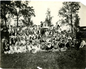
In 1885, Goucher College was founded in Northern Baltimore as the Women’s College of Baltimore. It then was renamed Goucher College in 1910 to honor the contributions of Dr. John Goucher and his wife Mary Fisher Goucher. As early as 1914, the college sought to move out of Baltimore, due to the fact that “the character of the immediate neighborhood of the College was then beginning to change so rapidly.” The college purchased 421 acres of land in Towson in 1921. When the students first ventured to the Towson campus, the school newspaper described it as a visit where students “rambled for miles through the meadows, cornfields and woods that in a very few years will have been metamorphosed into the Academic Quadrangle, the Lake, Faculty Row, and everything else that one’s fondest dreams may suggest.”
The move was a time of great hope and anticipation, leading to a campaign where alumnae each raised $421 to fund the building of the new campus.
The land that became Goucher was originally owned by the Ridgely family as part of Hampton Estate. The Hampton Estate was one of the largest slave plantations in Maryland, before it was given by the family to their relatives, the Chew Family. The land then became the Epsom farm, which was still worked by slaves. When the college bought the land in Towson from the Chew family, it was stipulated in the deed that “that no part of said land or premises shall ever be leased, sold, transferred to or occupied by any person of the African Race; this provision, however, not to apply or include occupancy of servants, or employees of the owners of the premises.” Even after the sale, members of the college upheld a close neighborly relationship with the then owner of Hampton Estate, Captain Ridgely.
The move from Baltimore to Towson began in 1921 but was not completed until 1954, due to financial difficulties and building supply shortages during World War II. The 1950s was also a period during which white-flight was happening across the United States and in Baltimore, as white residents of cities moved out of the city center and into the suburbs and more people of color moved into the cities. In 1937, the Residential Security Map of Baltimore had been created, which is now known as a redlining map, meant to prevent the sale of property to people especially people or color and the poor who lived in certain geographic areas, particularly those in the inner-city. In this map “desirable” mostly white neighborhoods were marked as green, while “undesirable” neighborhoods with high lending risk were marked red. Through this effort and through neighborhood covenants, people of color were excluded from living in certain neighborhoods and were refused housing loans and insurance. This map was created by a number of real estate brokers as well as with help from Ivan McDougal, Professor of Economics and Sociology at Goucher College.
In summation, the history of the campus is far more complicated than is regularly acknowledged. This information is all available from the Goucher archives, which can be found online at http://blogs.goucher.edu/digitallibrary/.
If you are interested in learning more about this history or simply discussing what you know about the history and how it affects the college today, please contact me (Sophia Hancock at sohan001@mail.goucher.edu)! I am currently conducting a research project on the history of the campus as a part of my Environmental Studies capstone project.
SOPHIA HANCOCK


Be First to Comment